Prairie City Fire Finder

Oregon Lookouts

Location.

Grant County, OR

Status.

Emergency; Currently standing

Estimated drive time from Portland, OR.

6 hours

Date visited.

July 9, 2023

Elevation.

3,660′

National Historic Lookout Register.

US 1637; OR 155

Trip Report.

Day 2/9: Lookout Road Trip 2023

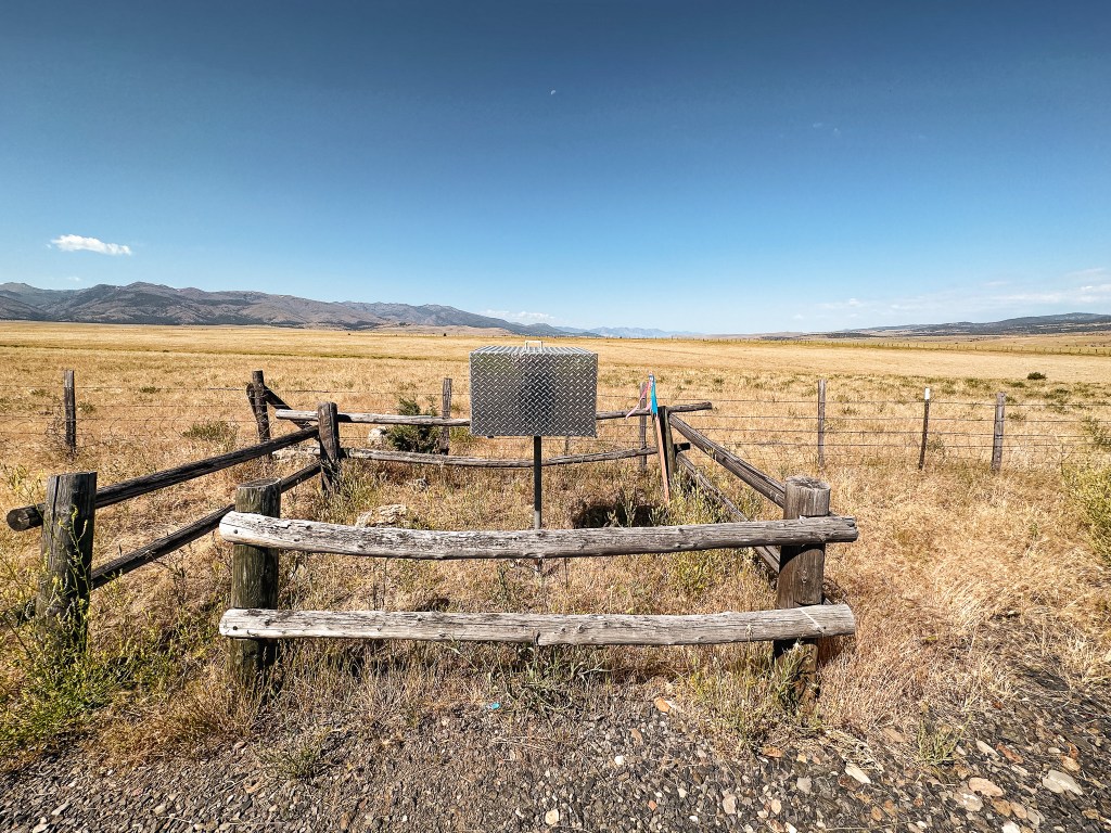
We packed up our camp and headed out of the Starr Campground before 9AM. Our next stop was an easy one. We headed North on HWY-395 towards Canyon City and John Day. We had plenty of gas in the tank, but decided to refuel and fill our Jerry Can in Canyon City. We didn’t want to make the same mistake from our Memorial weekend trip (post). Over the next few days we would be driving through the forest without any access to services. This made our water and gas refills a bit trickier than normal. Once in John Day, we turned right to head farther east on HWY-26 to Prairie City. There are no signs in town that will point you in the right direction of such fire finder, but it’s on the same route you’d take to get to the Strawberry Lake Campground. From Prairie City, we turned right on S Main Street and then left on SW Bridge Street. There is an almost immediate right turn onto to S Bridget Street after this. We followed this road out of town until it turned into CR-60 and Strawberry Road. You will see the box on the right hand side of the road with a small pull out for one or two vehicles. This is an easy pitstop to see some fire finding history if you are ever in the area.

History.

A stand alone Osborne fire finder was built just a mile outside of Prairie City to be used for fire detection in the early 1930s. It is secured in a locked box and used only in emergencies during heavy lightning activity. The box used to be wooden but was replaced sometime between 2016-2018 with a more robust metal box. It has a direct view of the Strawberry Mountain Wilderness with some surrounding views of the Malhuer NF.

Ritter Butte L.O.

Oregon Lookouts

Location.

Grant County

Status.

Fire Detection Camera; Currently standing

Estimated drive time from Portland, OR.

5 hours

Date visited.

May 29, 2022

Elevation.

4,204′

National Historic Lookout Register.

US 658; OR 109

Trip Report.

From the Malheur NF, we headed farther north on HWY-395 towards the community of Dale. On the drive, we contemplated whether it made more sense to stop at Ritter Butte today or back track to it tomorrow. We didn’t have much day left to search for a camp but Ritter Butte was along the way. Our decision was quickly made when we realized we could see Ritter Butte from HWY-395. We knew it was only about a half mile off the highway but seeing how close it was for ourselves made it an easy decision to stop. The turn will be marked as Old Ritter Lane on the left once you reach the highway summit for Ritter Butte. The access road is the first un-marked road off to the left. They recently added a gate to deter people from driving to the summit. We parked in a pull out on Old Ritter Lane and made the short hike up. The road was also made up of large rocks instead of fine gravel, so I wouldn’t have tried to drive up anyway.

The summit was filled with wildflowers that were beginning to bloom and we even had a small break in weather. There were newer power tools and fresh wood stored in the bottom shed portion of the lookout. It looked like they were working on replacing or updating the structure. We thought this was odd since it is no longer actively staffed, but speculated it needed to stay up to date for camera maintenance. Someone had completely removed the trap door for the catwalk and the second level was unlocked. We decided to take a quick look on the open catwalk since it seemed to be in somewhat decent shape. We once again didn’t stay too long on the summit due to time constraints. But this one is an easy on and off if you’re ever passing through the area. We quickly popped on HWY-395 again and continued on to the Umatilla NF. We were headed up towards Bone Point L.O. (post) and hoped there would be a dispersed camp spot somewhere along the road.

History.

The Ritter Butte L.O. is a 3-story enclosed ODF tower with live-in cab and was built in 1950. It was actively staffed into the 1980’s and then moved to emergency status. There are multiple sources stating that it was actively staffed again in 2012, but it is unclear if it was just for that season or for a few years after that as well. In 2017, similar to other ODF lookouts, a fire detection camera was installed and will be the main source for fire detection.