Green Point L.O.

Former Lookouts, Oregon Lookouts

Location.

Siuslaw National Forest; Cascade Head Experimental Forest

Status.

Abandoned; Partially standing

Estimated drive time from Portland, OR.

2 hours

Date visited.

April 23, 2022

Elevation.

1,303′

Former Fire Lookout Site Register.

US 711; OR 122

Trip Report.

Green Point, not to be confused with Green Mountain, Green Butte, Green Peter, or Green Ridge, is a crows nest located outside the community of Otis within the Oregon coastal range. You can access the community of Otis via HWY-101 or HWY-18. From Otis, you will want to follow the Old Scenic Highway towards the Cascade Experimental Forest Headquarters. Continue on past the headquarters until you reach a four way junction. Turn right here onto NF-1861 until you reach the road with a gate off to the left. Park here. All roads were in good condition for driving a low clearance vehicle.

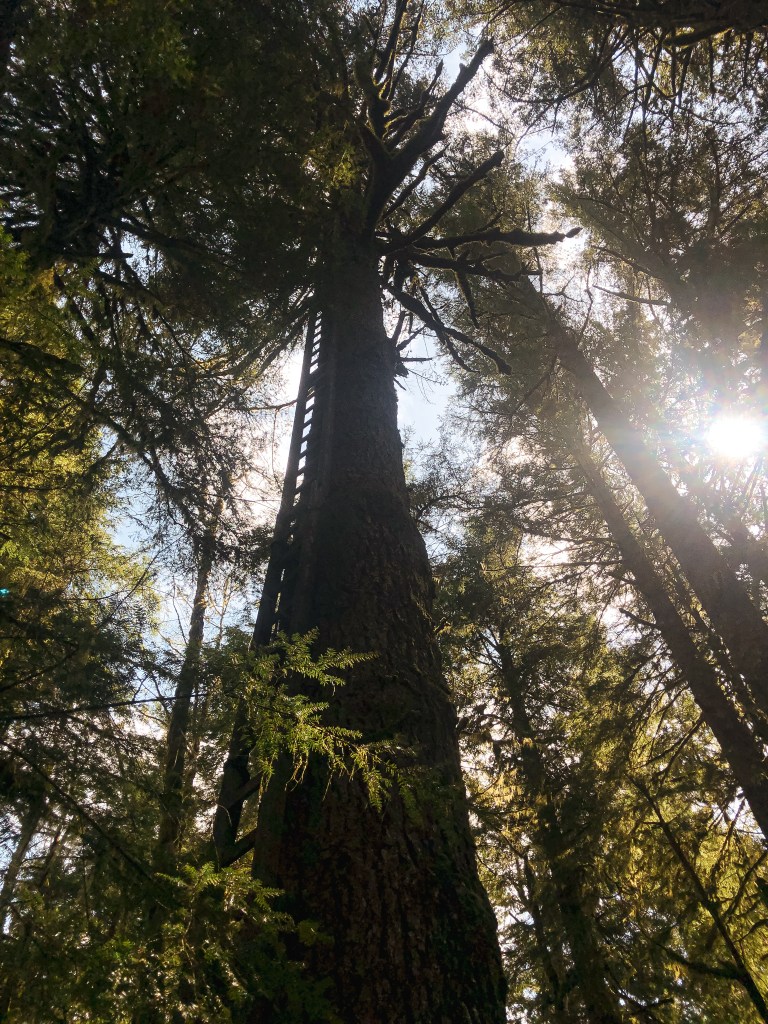
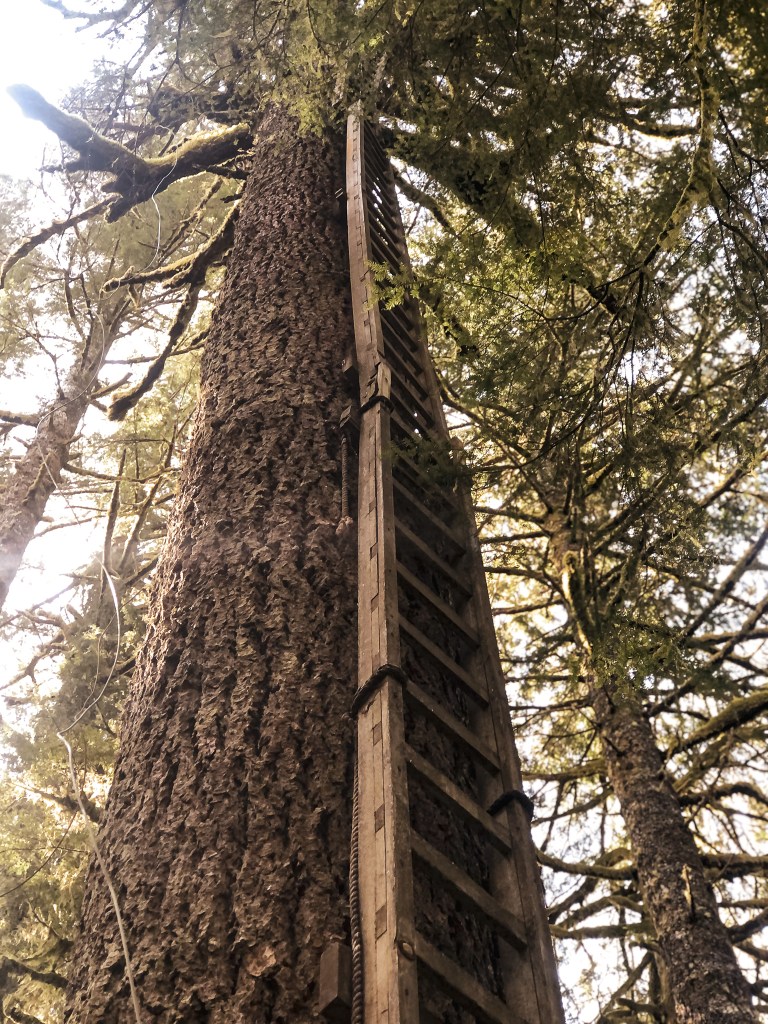
The above map shows our rudimentary route. The black dots indicate our driving route with the larger dots representing Otis, Green Point, Cascade Experimental Forest Headquarters, and our parked car. The purple indicates our hiking route. We parked the car in a pull out across from an old road with a gate. You could potentially park at the gate, but someone was already parked here during our visit. I’m not sure what they were doing since they were just sitting in their car, but I’m sure they thought the same about us. Especially, after we headed uphill into the brush. We had drove to the junction past this gated road initially because there was supposed to be another road off to the left that headed closer to the summit. We weren’t able to find any indication of an old road along this section. We hiked a bit up the gated road, but it just followed around the point. It was also significantly overgrown and brushed over by prickly berry bushes. It seemed easier to head cross-country to the summit instead. We started up at an angle from the junction towards the high point. It was fairly easy and open walking for a while, but as we grew closer to the summit we were met with downed trees and thicker brush. I didn’t expect it to be a walk in the park, it is the coast range after all, but this section made me want to turn around. My partner encouraged me to continue on and we eventually broke through into another open area. We followed some game trails until we reached the plateau that is Green Point. It is fairly flat on the summit with a nice park-like stand of trees. We searched around for a while until we found the correct tree. It was on the more northern side of the summit right before it slopes down again.

Heading back down, it was much easier to find a more open route that avoided most of the brush. We were even able to find the old road bed. It was only visible due to the cut bank, otherwise completely overgrown. It was virtually invisible from the main road and un-walkable. Actually, the whole area was overgrown near the main road. We had to push through a dense thicket to get back on the road to our car. There were two bikers stopped and talking on the road where we were headed out. I’m sure they were caught off guard when we emerged out of the brush for no apparent reason. We tried to act casual and headed back to the car. The only marker to identify where to start is a paper plate nailed to a tree with a 3 spray painted on it. This is the better route even if it might not look like it from the road.

History.

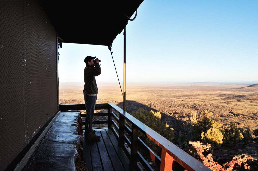
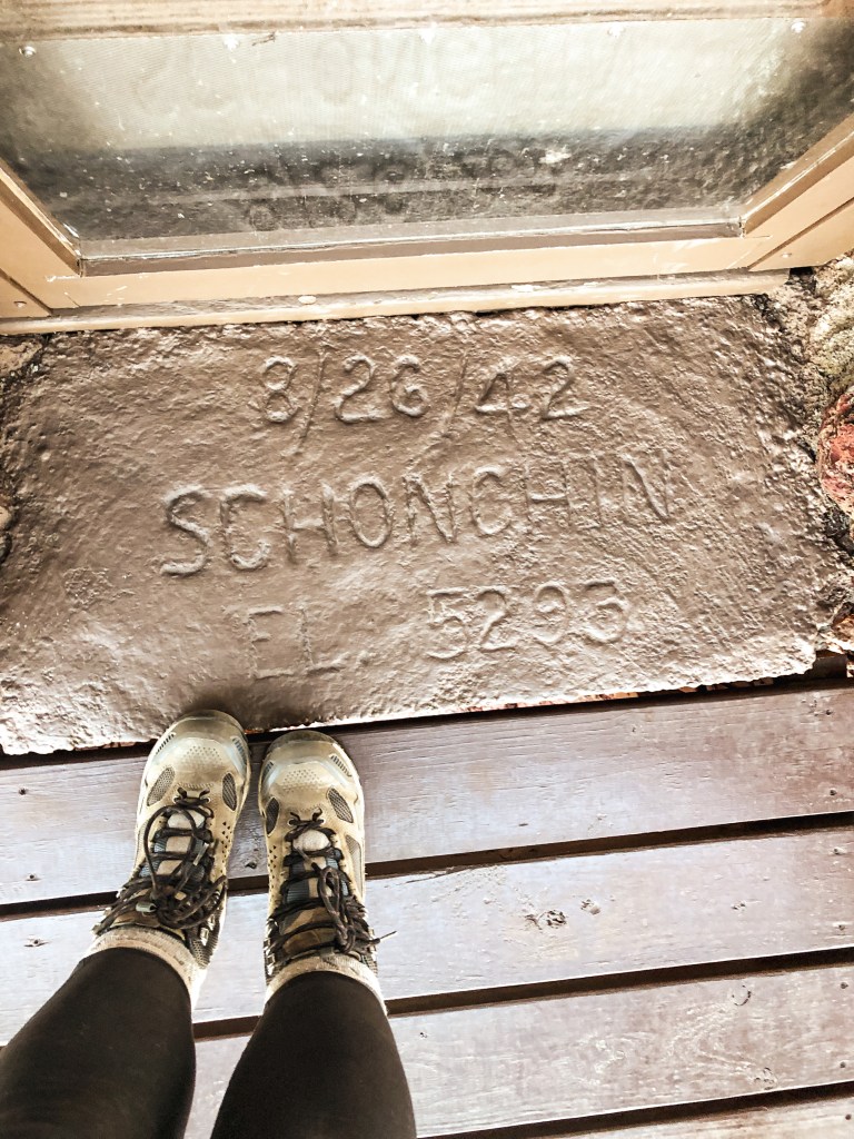
Green Point used to have a 53′ pole lookout tower with L-4 cab and garage built by the CCC in 1939. It was used for aircraft surveillance in 1942 and later destroyed in a windstorm during 1951. The crows nest pre-dates the tower and was added to the summit in 1933. I’d say this one doubles as a former fire lookout site and existing lookout.

Timber Mountain L.O.

California Lookouts

Location.

Modoc National Forest

Status.

Active; Currently standing

Estimated drive time from Portland, OR.

6 hours

Date visited.

April 10, 2022

Elevation.

5,071′

National Historic Lookout Register.

US 1333; CA 156

Trip Report.

After deciding to visit Lava Beds NM, I wanted to see if there were any other fire lookouts close by that would be accessible. Unfortunately, there isn’t an equivalent map to Rex Kamstra’s fire lookout page for California, which is helpful in finding fire lookouts within the same area. I was able to find Timber Mountain L.O. after doing a bit of research. My partner downloaded the quadrangle map and the route looked simple enough. We figured in the worst case we would run into snow on the road but would be able to hike the remaining distance. We headed out in the morning towards the southern entrance of the Monument and the small community of Tionesta. The main paved road eventually turns into NF-10 that you will follow until it comes to a T-junction with CR-97. From the junction you will turn left. From here we were a bit turned around. The map shows that all the roads should connect but this is not exactly the case. We turned right on to CR-97A which leads to Eagle’s Nest RV Park. The road does in fact connect but there is a private party that has blocked the route with a gate. We headed back out to the main county road and turned right at the next CR-97C. We followed this road until it came to a three way junction. You will want to continue straight over the cattle guard on to road 44N18. This road will take you all the way to the summit. The road is well maintained gravel with only a few hazards. We were surprisingly able to drive all the way to the top in my Civic. There is a gate 1/2 mile from the summit that might be closed during different times of the year, but we found it open during our visit. We enjoyed the lookout to ourselves with lunch before heading back to the Monument for some caving. This was definitely one of the easier fire lookouts to access thus far.

Looking towards Lava Beds NM & Schonchin Butte L.O.
Timber Mountain L.O. From Indian Wells CG

History.

This site was recorded for administrative use as early as 1912. There isn’t much information on what structure, if any, was used back then besides a platform. There are remnants of an old foundation that can be found next to the existing lookout where the old platform used to sit. It is recorded in the National Historic Lookout Register that there was a previous L-4 or Region 5 BC-101 structure used from 1934. The current fire lookout was built in 1966 as a CL-100 plan with 30′ steel tower. It is even outfitted with running water and electricity. The Forest Service still actively staffs this lookout every season.

Old foundation

Tule Lake National Monument/Wildlife Refuge

California Lookouts

My partner found these two structures when researching other potential fire lookouts to visit in the area. Unfortunately, neither of these ended up having any recorded history in fire detection but were still interesting in their own unique way.

Sheepy Ridge Overlook

Date visited: April 8, 2022

We wanted to stop at this overlook on our way into the Lava Beds National Monument since it’s located on the same route but accidentally drove past it. We had some extra time in the day before sunset and were able to drive back out after setting up camp. It’s only a short 30 min drive from the campground. This overlook was built from lava rock by the CCC in the 1930s for observation purposes. We hoped there might be some history of it being used as a fire lookout but I was unsuccessful in finding any information. It is located behind the Tulelake National Wildlife Refuge Visitor Center and is a short hike up. The trail is only 0.5 miles and climbs 170ft of elevation. From the overlook you have a great overview of the wildlife refuge and part of the Klamath Basin.

More Information.

National Wildlife Refuge

Tulelake-Butte Valley Fairgrounds Museum

Date visited: April 8, 2022

We passed through the town of Tulelake while heading to the Lava Beds NM for the weekend. Located just outside the town is the Tule Lake National Monument. This National Monument is the site of the Segregation Center and Camp Tulelake which were used to detain Japanese Americans during World War II. The visitor center is temporarily located at the Tulelake-Butte Valley Fairgrounds along with some other important exhibits. The Rangers only staff the National Monument from Memorial Day through Labor Day. We wanted to make a quick stop at the visitor center since there appeared to be a fire lookout based on pictures online. One of the fairground employees that was working there was nice enough to let us view the exhibits onsite. We found that what we thought to be a fire lookout was actually an observation tower used by the guards at the camps. There are a lot of great historical artifacts at this location from this dark period in history and it is worth the stop if you are in the area.

More Information.

National Park Service

Schonchin Butte L.O.

California Lookouts

Location.

Lava Beds National Monument

Status.

Staffed; Currently Standing

Estimated drive time from Portland, OR.

5-1/2 hours

Date Visited.

April 8, 2022

Elevation.

5,302′

National Historic Lookout Register.

US 1358; CA 181

Trip Report.

I had a four day weekend set aside to celebrate my 30th birthday this year. My original plan was to knock off a bucket list backpack to the Enchanted Valley in the Olympic NP but the weather forecast had other plans. With severe winter weather warnings across the state of Washington and Oregon, we decided to look farther south. I had never heard of Lava Beds National Monument until the week before when I was researching other options. It ticked all the boxes for what I was looking for in an alternate plan; somewhere my partner and I hadn’t been before, a sunny weather forecast, snow free, a fire lookout, and within reasonable driving distance for an extended weekend. We left Friday morning and spent the day driving across Oregon to the California border. There are multiple routes you can take to get to Lava Beds NM, but we took HWY-39 from Klamath Falls because wanted to stop in Tulelake beforehand to see part of the Tule Lake National Monument (post). There is a lot of history in this area that is often overlooked in our school systems and it is worth seeing first hand. We arrived at the Lava Beds NM early afternoon and had our pick of the camp spots in the Indian Wells campground. There was some daylight left after setting up camp and we decided to visit Sheepy Ridge Overlook (post) and Schonchin Butte L.O. for sunset. The hike up to Schonchin Butte L.O. is a short 0.7 mile trail that climbs 500′ in elevation to the top of a cinder cone. There is a signed road off the Volcanic Legacy Scenic Byway that you will take to get to the trailhead. It is a well maintained gravel road and drivable by any vehicle. We reached the summit just before sunset and enjoyed the lookout to ourselves. It was very windy and cold on the catwalk, but the sweeping views were worth it.

We spent the next few days checking out other points of interest in the park and drove out to see Timber Mountain L.O. (post) as well. Lava Beds NM offers a variety of things to do from caving their developed caves or hiking along historic sites. But no matter where you go in the park there seems to be a view of Schonchin Butte. Part of the Monument was still closed during our visit due to damage from the previous years wildfires. They also close some of their caves in the winter for hibernating bats that were still in affect. If you do plan on visiting any of their caves, you will need to stop at the visitor center for a caving permit and be aware of their protocols on White-Noise Syndrome. Despite having clear skies the first three days, we woke up to snow on our last morning. We quickly packed up camp and started our long drive home. The entire state of Oregon seemed to have been blanketed in snow as well. This meant avoiding all the high passes and taking the long way home.

Schonchin Butte from Fleener Chimneys
Schonchin Butte from Indian Wells Campground

History.

The cinder cone that makes up Schonchin Butte is one of many eruption sites from over 65,000 years ago on the Medicine Lake Shield Volcano. A shield volcano is a low profile volcano that is named after its resemblance to a warrior’s shield laying on the ground. These types of volcanos are formed from highly fluid lava that travels farther creating a thinner profile. The cinder cones are then made from a glassy rock filled with gas bubbles called scoria. Schonchin Butte’s large cone was developed from the initial eruption throwing scoria high in the air. The bowl shaped crater on the summit was created from trapped gasses below releasing and causing the lava to become heavier.

The lookout and trail on Schonchin Butte were built by the CCC camp stationed in Lava Beds. Construction started in 1939 and wasn’t completed until 1941. The CCC camp there contributed to making the monument what it is today. They even hand carried the needed materials to the summit which included lumber and cement. I couldn’t find specific information on the type of fire lookout since California designs are slightly different than Oregon, but it resembles a flat top R-6. The doorstep on the lookout has a date of 8/26/42 which is noted as the day it was installed. The elevation is also on the doorstep at 5,293′ but was later found to be 5,302′ by modern technology. Over the years the lookout has been updated and changed, but the physical structure has remained the same. The most recent renovations took place in June/July of 1994. The lookout is still staffed every summer from June to September, but the rangers no longer live in the lookout.

More Information.

National Park Service

AllTrails