
Location.
Rogue River-Siskiyou National Forest
Status.
Abandoned; Currently standing
Estimate drive time from Portland, OR.
7 hours
Date visited.
May 26, 2023
Elevation.
3,033′
National Historic Lookout Register.
US 467; OR 64

UPDATE: As of 11/21/2024, it is heavy for us to report the cab on top of Quail Prairie has officially collapsed. I believe the wind from the recent Bomb Cyclone along the west coast was the main cause aside from the years of neglect. My partner had checked the Alert West camera on Monday and said it had still been standing at that time. The Bomb Cyclone was due to hit this Tuesday through Wednesday. We discovered it had since collapsed when he pulled it up to show me the camera view of it before work. The tower still remains standing for now.
Trip Report.
The high holiday weekend was upon us and snow was still lingering lower than previous years. Similar to a relative that has overstayed their welcome. Memorial weekend is usually considered the official start of the camping season for the general population. But, I think a lot of plans changed as reservations were cancelled and campgrounds failed to open in time. We typically like to start our season earlier by creeping our way into the lower elevations as early as March. This year had been slow to start with the snow levels and our added responsibilities as new home owners. We still managed to make it to the Northern Redwoods for my birthday in April and Eastern Oregon for my partner’s birthday in May. Despite those two previous trips this felt like our first substantial trip of the season. It would also formally kick off our fire lookout season. Though I don’t think we’ll be able to top last year after visiting a little over 50 standing lookouts in one season. Our plan for the next 5-days was to take a tour of the fire lookouts within the Southern Oregon coast range. We figured they were all low enough elevation to be snow free by this time. Plus the coastal range tends to get less snow in general than the rest of the state. There were a few posts about rental reservations in that area being cancelled on the Oregon fire lookout Facebook page that were some cause for concern. But, we didn’t really have a plan B in mind and decided to leave it up to luck. We would only pivot and reroute if absolutely necessary.

My partner and I stayed up late Thursday packing the car and prepping the remaining items for the trip. No more packing our gear down three flights of stairs the morning of departure! We also didn’t have to get up as early with the car already packed, minus the cooler of food. We just had to make sure to leave early enough to make it to Gold Beach before their ranger station closed for the weekend. We were on the road by 9AM heading south via the I-5 corridor to cut over on HWY-38. There are a few different options to connect to the coast, but HWY-38 offers the least amount of curves and is flatter than most. We met up with HWY-101 from Reedsport and continued heading south. The Gold Beach ranger station closed around 4:30PM and we made it in time with an hour to spare. The ranger on duty was very helpful. He confirmed their current snow levels were around 5,100′ with a few lower elevation snow drifts in the northern slopes. This was good to hear since all the fire lookouts we planned to visit were around or below 4,000′. We told him our intended route and asked about road conditions. He thought we should be fine getting to most, even in our Civic, but he didn’t recommend Snow Camp or Eden Ridge. The last report on Snow Camp was from the previous Tuesday where there was still 14″ of snow on the road. I took that as the entire summit being covered in snow, but more on that later. He cautioned around visiting Eden Valley due to some recent timber theft and a few land slides in the area that they still needed to clean up. Our plan was to head to Quail Prairie after our visit to the ranger station and camp in that area for the night. Another ranger showed up while we were talking about this plan and they confirmed that area was accessible to at least Packer’s Cabin, which is located 3 miles below the lookout and rentable through the Forest Service. She cautioned us to be very careful heading up the Chetco River though due to the high traffic on a very narrow road. We bought a ranger district map of the area and thanked them for their helpful information.
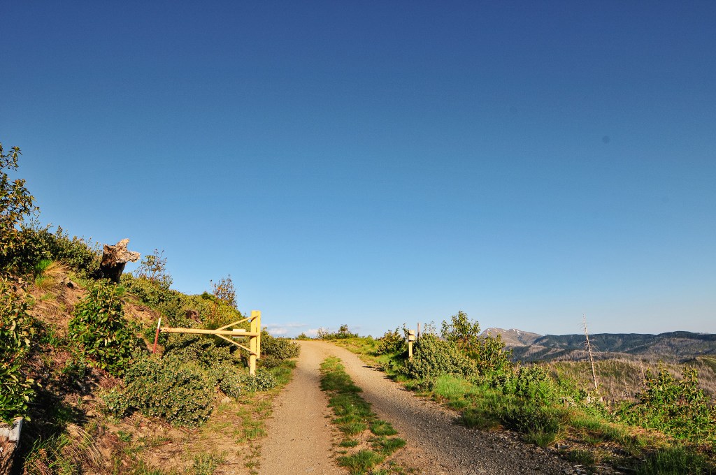


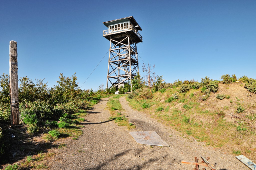
We headed back out on HWY-101 continuing south to Brookings. We wanted to start with the southern most fire lookout and slowly work our way back north to set us up for a shorter drive home. From Brookings, we turned left onto the N Bank Chetco River Road to head into the forest. This is a narrow paved road that winds along the edge of the Chetco River with steep drop offs as the ranger had mentioned. There were a few gravel bar campgrounds along this route that were filled to the brim with campers. The pavement was in good shape minus one spot before the last campground that drops down due erosion. If you’re not careful you could bottom out. We were able to crawl over this at an angle and others had driven their trailers beyond this section. After passing the last campground, we crossed the South Fork of the Chetco River on a single lane bridge and came to a T-junction. We turned left onto NF-1376 and the pavement ended. We weren’t on this road for very long before we came to a major fork. The NF-1376 road continues to the left along the Chetco River, but we turned right to start our climb up NF-1917. Shortly after starting up this road, I let Garnet take over the driving when the road made a dip on a narrow section. No use in wasting our time having me freak out while driving. The NF-1917 road climbs up along Long Ridge and past the Packer’s Cabin. As we got closer to the summit, there were some downed trees along the road. Luckily, the wood cutters had been through here and cleared just enough room for us to make it around. The spur road NF-180 for the lookout will be obvious since there is a gate and you can see the tower from the road. The road continues past the spur but turns into an unmaintained jeep track from there. We parked at the junction and decided to walk the remaining distance. The Strava App tracked the road walk at a little under half of a mile to the summit. The gate was open and we probably could have driven the Civic up, but we were both ready to stretch our legs after a full day in the car. The roads getting here had been decent with a bit of caution needed over a few bumps and dips.
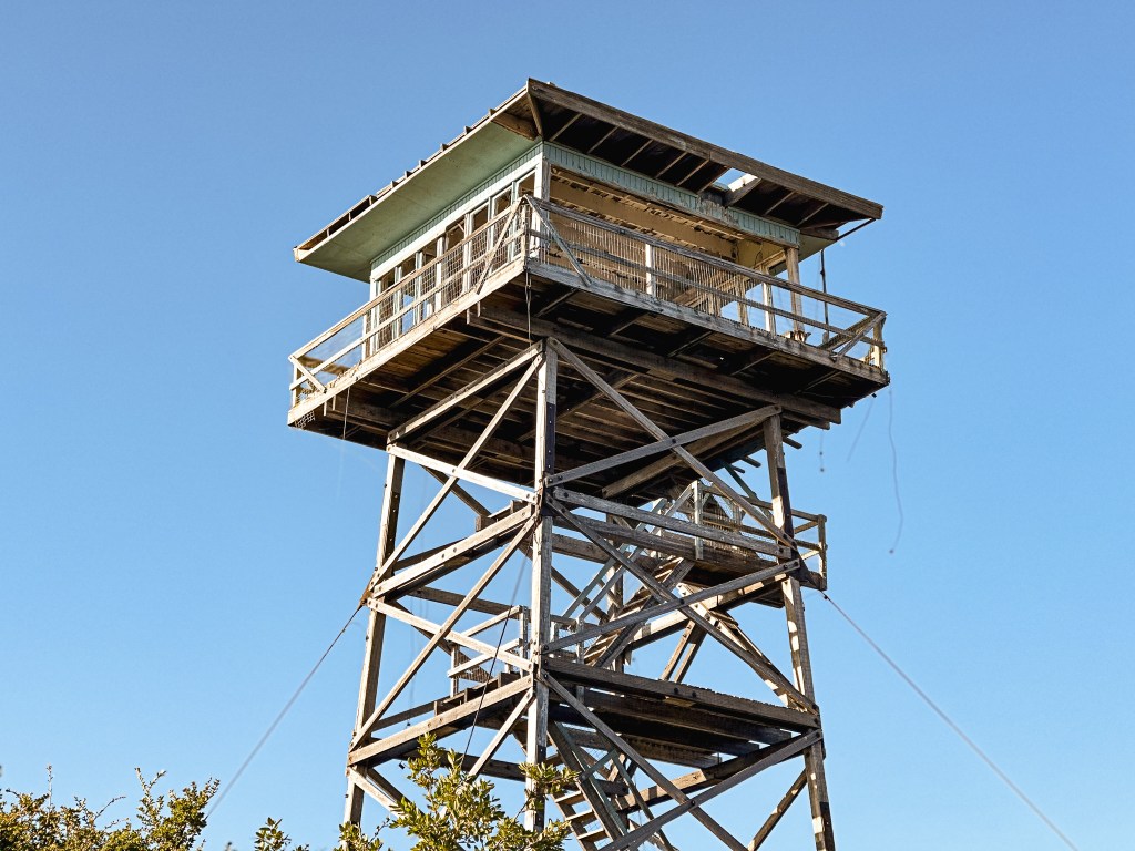


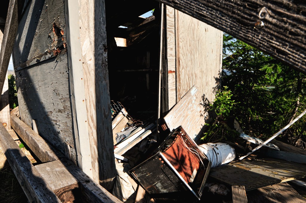
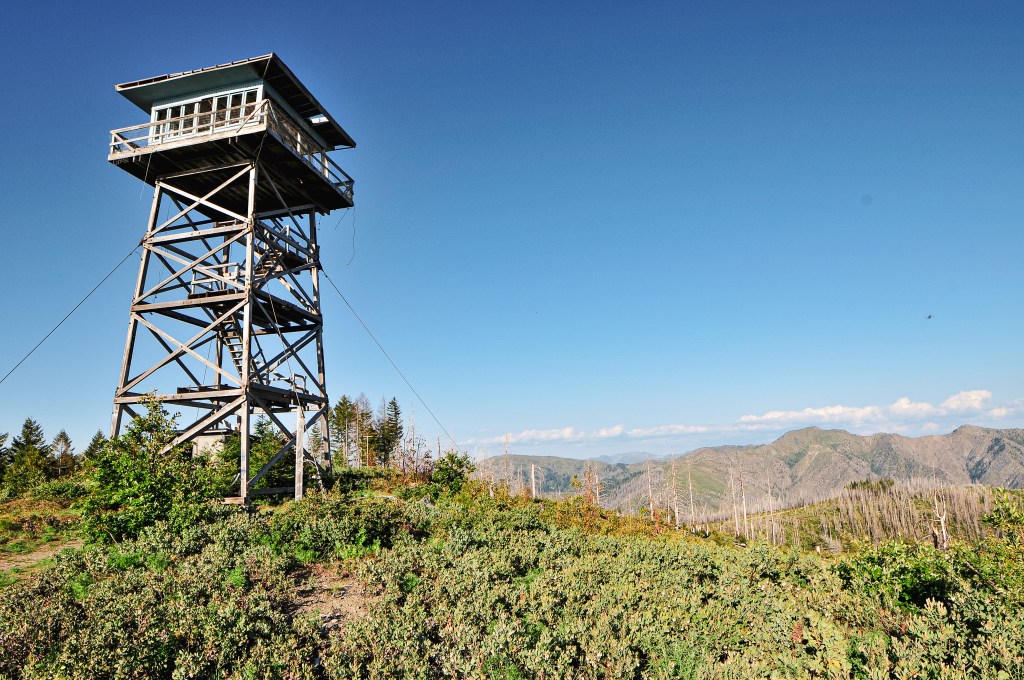
The fire lookout looks similar to Bald Butte in the Ochoco NF given that it is completely missing a wall on the R-6 cab. The first flight of stairs have been removed to keep visitors from climbing the tower. There is no glass in the windows either, but I’m unsure if they were intentionally removed or just broken. The storage shed has since been rummaged through with items tossed from it haphazardly. There was graffiti and trash on the summit that indicated people come up here fairly often too. It is a bit sad to see given that this was on the rental program as recently as 2007 and the Forest Service still lists it as closed for repairs. But, it seems the time and place for repairs has come and gone. It just goes to show if you don’t put in the maintenance on something how quickly it will fall into disrepair. It still stands and could possibly be salvaged if the local community found an advocate team for it through the FFLA. But, that is part of the problem it seems. The FFLA calls for more leaders and local chapters in their recent magazine, but I’ve learned you can’t force people to care about fire lookouts. You can only inform them about things they didn’t already know. Then you have people, such as Garnet and myself, that care but lack the skills or know how or are not centrally located to be of any help. Places like this will continue to fall into disrepair for that reason alone.
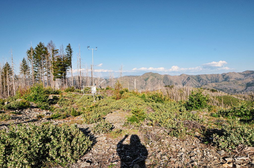


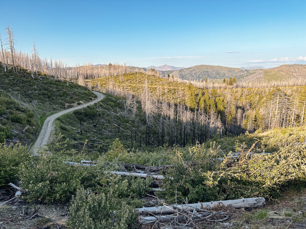
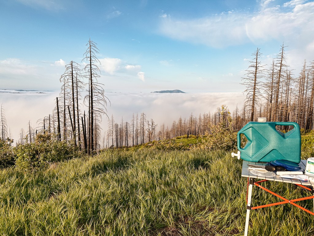
The area had been burned over a while back which opened up the views from the summit and road. You are mostly overlooking the peaks of the Kalmiopsis Wilderness. We could even spot Pearsoll Peak in the distance. Unfortunately, it was already late in the day when we arrived which gave us little time to explore. We briefly debated just camping on the summit since there were no official dispersed camp spots along the road. That was one down fall we encountered all weekend, the camp spots seem to be few and far between in the coastal range unless it was an established campground. The peaks might not be that high here, but you still have to climb up from sea level which leaves little flat areas to camp. We ultimately decided not to camp on the summit since there was a nice grassy landing a few miles below that I preferred instead. A cloud inversion started to roll in around sunset and stayed through the night into the late morning. It was gorgeous!


History.
Quail Prairie was built in 1963 and one of the last fire lookouts to be built by the Forest Service in southwestern Oregon. It was considered an important fire detection facility for this area due to the limited established road systems. The tower is a 41′ treated timber with 8×8 wooden legs and R-6 flat cab. It was built as a replacement for the neighboring Long Ridge L.O. that was destroyed during the Columbus Day Hurricane in 1962. The Forest Service actively staffed it up until the mid-1990s. It was moved to the rental program sometime after that until it was damaged in the early 2010s. It sustained substantial damage to the side causing part of the wall to buckle. I assume this is the same wall that is currently missing from the cab. It used to be furnished with a single bed, table, two chairs, a stool, broom and fire extinguisher. It also used to feature a wood burning stove, propane stove, and propane fridge. It has since been abandoned and fallen into a state of disrepair.


One thought on “Quail Prairie L.O.”